Wednesday 17 January 2018

Thattekad Bird Sanctuary

Thattekad Bird Sanctuary


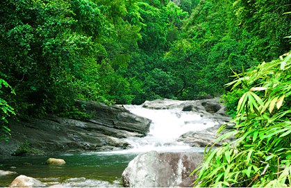
Blessed with so many natural wonders, Thattekad is a picturesque destination, masked in the glory of abundant flora and fauna. This wonderful place is positioned on the Njiyapilli Hill and is mainly famous for the Salim Ali Bird Sanctuary, named after the great Ornithologist, Dr. Salim Ali. This sanctuary was established in the year 1983 by the Kerala Government, on recommendation of Dr. Salim Ali in the early 1930s. This is the most popular bird sanctuary of India and houses about 280 rare species of water and land birds.


The scenic beauty of Thattekad Bird Sanctuary cannot be described in words, it can only be felt and enjoyed! Visit India's most beautiful,

Thattekad Bird Sanctuary and catch a glimpse of some of the most amazing birds and their landscapes that are hard to overlook. Sprawling over 25 km sq and at the distance of around 60 km towards the north-east of Kochi, Thattekkad Bird Sanctuary is located in the Kothamangalam Taluk of Ernakulam district on the northern bank of the Periyar River. In the year 1930, Dr. Salim Ali discovered Thattekad as the richest bird habitat of peninsular India and it was named as a Bird Sanctuary in the year 1983. Since the forest is covered with a huge variety of tropical deciduous and evergreen tree, it offers a safe paradise for birds. Hence, it's an interesting place to visit for birdies and wildlife enthusiasts.


FLORA & FAUNA

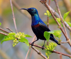
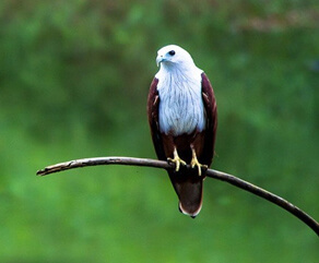
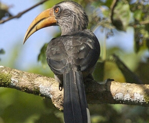
The sanctuary is home to Ashy Wood Swallow, Black Headed Oriole, Ash Tail, Ashly Drongo, Bronzed Drongo, Blue Kingfisher, Bronze Winged Jacana, Ceylon Frogmouth, Created Woodpecker, Crested Goshawk, Changeable Hawk Eagle, Chestnut Headed Bee Eater, Coucal, Dollar Bird, Emerald Dove, Eurasian,Golden Oriole, Greater Raquet Tailed Drongo, Lora, Orange Minivet, White Breasted Woodpecker, Jungle Myna, common Myna, Indian Pitta, Jerdons Nightjar, Indian Cuckoo, Yellow-browed Bulbuls, Darters, Sunbird, Shrike, and many more.

MUST SEE PLACES & THINGS TO DO IN AND AROUND

Most exciting part about birdwatching holiday in Thattekad Bird Sanctuary is that here one get an opportunity to do kayaking. Apart from enjoying the birdwatching safari, one should visit some attractions near Thattekad Bird Sanctuary like Nadukani, Bhoothathankettu, Malayattoor, Kodanad, Kalady, Wellington Island, Bolgatty, Mattancherry, etc.

HOTELS IN AND AROUND THATTEKAD SANCTUARY

For a perfect bird watching vacation, there's nothing better than the iconic Thattekkadu Bird Sanctuary of Ernakulam. There are a lot of accommodation options available within the sanctuary, that offers the most relaxing stay to the visitors. One can find a Forest Department inspection bungalow 'Hornbill', and a dormitory inside the forest area to give the tourist a better access to the jungle. For people who want to stay a little away from the sanctuary can book a homestay or lodge in Kothamangalam. The three-story watch tower inside the sanctuary also offers stay facilities to the people with two beds, a toilet, and a kitchen. To adventure freaks who want to spend a night in tents nearby the jungle area can take camp facilities outside the sanctuary on the Southern side of the river.

INTERESTING FACTS

  • Thattekad is a home to one of the most popular bird sanctuary in India ‘Salim Ali Bird Sanctuary’
  • Thattekad is one of the best spots for birding in India
  • The sanctuary is named after the great Ornithologist, Dr. Salim Ali, who found that this area attracts the highest number of birds in India
  • There are more than 500 species of birds in the sanctuary, along with a few wild animals like elephants, leopards, sloths, and other mammals
  • This area has a large quantity of teak and mahogany cultivated
  • The forest has Sloth bears, Porcupines, leopards, elephants, and many such mammals living
  • Around 250 bird species have been recorded in the small area

POOKOT LAKE WAYANAD


LOCATION

The Pookot Lake, located 3km south of Vythiri town, is the most frequented tourist spot in the entire Wayanad district of Kerala. A must-visit destination on your Kerala tour, this beautiful fresh-water lake is at a distance of 13 km from Kalpetta.

ABOUT POOKOT LAKE

The most important tourist destination in Wayanad, Pookot Lake is a natural fresh water lake nestled amidst evergreen forests and wooded slopes. Surrounded by lush greenery all around, this idyllic lake, with its breathtaking scenic beauty and peaceful ambience, mesmerizes every visitor on tour to Pookot Lake. The pathway around the lake is lined by thick bushes and tall trees which further add to the overall charm. One of the main tributaries of the Kabani River – the Panamaram rivulet originates from Pookot Lake and then tumbles down into Panamaram valley. A fresh-water aquarium filled with an excellent array of fishes is a major attraction for tourists on their tour to Pookot Lake. The recreational facilities at the spot include Boating in the lake, Children's Park, and Handicrafts and Spices Emporium.

The pleasant weather, combined with the scenic beauty and hypnotizing charm of the region promises to make your tour to Pookot Lake a thoroughly rejuvenating and memorable experience.

TOURIST PLACES NEAR POOKOT LAKE

PAKSHIPATHALAM

An idyllic hill resort located in the Brahmagiri hills, 7 km north-east of Thirunelli, Pakshipathalam is about 66 km from Kalpetta and it houses a wide variety of birds and animals.

KURUVADWEEP

Located in close proximity to Pakshipathalam, Kuruvadwep is a beautiful island, stretching for 950 acres on the banks of the Kabani River, 17 km from Mananthavady.

CHEMBRA PEAK

It is the highest peak in Wayanad, rising to a height of 2100m above sea level. Located 14 km west of Kalpetta.

FAIRS AND FESTIVALS

Wayanad being a major district of Kerala, it celebrates all major festivals of the state like Onam Festival, Thrissur Pooram, and others. But the festivals unique to this place include Thirunelli Festival – the two day annual festival of Sree Thirunelli Devaswom held in April, and Valliyoorkkavu Festival – the annual festival of Goddess Bhagavathy, held in March.

Wednesday 10 January 2018

PONMUDI

Ponmudi is connected to Trivandrum by a two lane highway (SH2 & SH 45). The last 18km starting from Anapara has scenic views, as it winds through the mountains and tea gardens. The travel along this stretch provides a thrilling experience as drivers and riders have to navigate 22 Hairpin turns.[tone] Ponmudi is also a popular spot for backpacking and trekking.[citation needed] The climate is pleasant year-round.[3]


Other attractions near Ponmudi include Golden Valley and a number of rivulets and rapids, some even across the road. The lush forest area has tropical vegetation.[4] A variety of wildlife inhabit the hills. The Golden Valley offers vistas of the hills and access to the Kallar River. Flowing though a wilderness area, it has rounded pebbles, cool water, fish, and lush green trees.

Some notable tourist attractions located in Ponmudi are Peppara Wildlife Sanctuary, Echo Point and various trekking spots. Mist-laden valleys, especially Golden Valley near Kallar River, also draw tourists. Travelers can find a deer park and wood and stone cottages coloured in bright hues while visiting here.Located about 1.5 km from the hill station, is the Ponmudi Falls. Around 3 km from the Ponmudi Resort, is the Deer Park. The Meenmutty Falls, another tourist attraction of the region, is about 3 km from the Kallar Main Road. Peppara Wildlife Sanctuary, located on the outskirts of Ponmudi, is a preserve spread across 53 km2 and accommodates a variety of wild animals and birds like Asian elephants, sambar, leopards, lion-tailed macaquesMalabar grey hornbills, etc.

Another main attraction in the region is Agasthyarkoodam, one of the highest peaks in the Western Ghats, with the highest peak at 1868 m. This peak is known for its wilderness, and can be accessed only with the Forest Department's permission. Agasthyamalai Biosphere Reserve is another attraction covering Neyyar, Peppara, Shendurney Wildlife Sanctuaries and divisions of Achencoil, Thenmala, Konni, Punalur, and Thiruvananthapuram

EcologyEdit

The landscape of Ponmudi is an interspersing of valleys and hills with forestland and plantations. Ponmudi is having an extensive importance of biodiversity, which plays a major role in maintaining the ecological balance of the area. Ponmudi is host to 283 species of birds, many of which are endangered and threatened.[5] Birds endemic to this region include the painted bush quail, the Malabar grey hornbill, the Wayanad laughing thrush, the broad-tailed grass bird and the Nilgiri pipit. The grasslands of Ponmudi are the breeding grounds of the broad-tailed grass bird, a threatened species. "Fifty-nine per cent of the 483 bird species in Kerala are found at Ponmudi. Of the 16 species of birds endemic to the Western Ghats, 15 are at Ponmudi. Of the 332 species of butterflies in the Western Ghats, 195 are found here. Of the 37 butterfly species endemic to the Ghats, 24 are found at Ponmudi. The spot puffin, a rare butterfly, has been sighted at the Kulachikarai-Panayam-Merchiston area where ISRO's land comes. Similarly, Ponmudi is also host to many species of reptiles and amphibians, including the highly endangered Travancore tortoise, the Malabar Gliding Frog and the Malabar tree toadNilgiri tahr is also found in Ponmudi hill top.


Kallar and Menmutty FallsEdit

Kallar situated en route to the hill station of Ponmudi, Kallar gets its name from the River Kallar, which flows through the region. Kallu means 'stone' and Aru means 'river', hence the name Kallar. The river is well known for its abundance of attractive, round-shaped boulders and pebbles, especially in the upper reaches and middle portion of its course. Here one can take a dip in the crystal clear waters to cool off, and also watch the many rapids and small pools that dot a good part of the river in this area.


Meenmutty Falls, Thiruvananthapuram is one of the main attraction located near by Ponmudi hills and is around 45 km from Thiruvananthapuram city.This waterfall is about 3 km away from the Kallar-Ponmudi road. The main attractions are water falls and the small natural pools and rocks located beside the way to the water fall. In order to reach the place, one has to take a long trek that passes through dense forests, upon taking special permission from the Forest Department. A guide will be sent along with tourist groups to the falls. Facilities for trekking are easily provided at Kallar Vana Samrakshana Samithi, which is a forest protection group at Kallar.


Cochin History

Cochin History


The port city of Kochi has a very colorful and rich history. It was formerly known as Cochin and used to serve as an important trading center in the ancient times. The city occupies a very strategic position geographically, being flanked by the Western Ghats on the east and the Arabian Sea on the west. It has, thus, long been a real enticing destination for travelers, traders and seafarers. Slowly it gained the reputation of being a significant spice-trading center.

In many ancient scriptures and history books based on Kochi, one will find that the ancient travelers and tradesmen who came to the city referred to it as Cochym, Cochin, Cochi and even Cocym. During those days, Cochin city of Kerala witnessed successive waves of migration by the Arabs, British, Chinese, Dutch, and Portuguese, who came here mainly for the purpose of trade. Many of these groups went on to reside in the city for sometime before migrating away to other lands. 

History before the Portuguese rule
The earliest account of Cochin is derived from the records made by the Chinese traveler, Ma Huan. Even in other documents belonging from the same period, the account of Cochin history prior to the Portuguese rule is quite vague. As per the available information, the city gained its reputation of being a port city only after the collapse of the Kulashekhara kingdom. These accounts also state that Cochin was invaded by foreigners and colonized many times. The king remained the titular head.

The Portuguese Period
The time during which Cochin was under the Portuguese rule is very interesting. It is said admiral, Pedro Cabral was sent by the Portuguese king to set up a factory at the city. The Raja of Cochin succumbed to the demand of the admiral, but mainly out of fear of the native Zamorins. Later, it was the legendary traveler Vasco Da Gama, who managed to pacify the Zamorins. The Portuguese then built Fort Manuel to protect their factory from any sort of attack.

Dutch Period
The Dutch rule over Cochin lasted from 1663 to 1795. They defeated the Portuguese and disposed the Cochin Raja. After landing confidently at Njarakal, they went on to seize the Pallippuram fort, which they later gave to the Zamorins. Cochin prospered under the Dutch rule by shipping pepper, cardamom and other spices, coir, coconut, and copper. The native ethnic religious groups in the city like the Hindus, Muslims, Syrian Christian and Jewish minorities too raked profits of the prosperity.

The British Period and Thereafter
The port city of Cochin had become highly developed during the time of the British rule in India. Later, this city became the first princely state to join the Indian Union willingly after India achieved Independence from the British rule. It slowly developed into not only a major commercial and industrial centre in the country, but also an enticing tourist destination. This reputation, Kochi has maintained till date.

Cherai beach

The 18 kilometer long Cherai Beach is the golden beach of Kerala and is rightly called "The Princess of the Arabian sea". Feel the warmth of the golden rays of sunset infront of our resort. Dolphins are seen here occasionally.

The beach is shallow, calm and is ideal for swimming & sunbathing. Enjoy a game of beach volley ball & take a dip in the sea. We provide all beach amenities like beach benches, towels, umbrellas etc. for your comfort.

The newly beautified main beach with the walkway adds to the charm and the Highmast lamp makes the beach enjoyable even at night.


Tuesday 9 January 2018

Nelliyampathy

Nelliyampathy


From the town of Nenmara in Palakkad district, the cloud-caressed peaks of the majestic Nelliyampathy hill ranges are a sight to behold. The height of the hills ranges from 467 m to 1572 m. To reach Nelliyampathy, one has to take the road starting from Nenmara that proceeds to the Pothundy Dam. There are about 10 hairpin bends that have to be negotiated on the way to Nelliyampathy.

The Pothundy Dam is a picturesque locale with facilities for boating and is a nice option as a picnic place. As the Ghat road winds its way up to Nelliyampathy, at certain places there are viewpoints from where the vast stretches of Palakkad district are visible with its extensive paddy fields forming a verdant carpet. It also offers a splendid view of the Palakkad Gap, which is a geographical phenomenon in the Western Ghats formation in this region, bringing into view, parts of the adjoining State of Tamilnadu.

On the way up, those interested in bio farming can take a close look at the privately managed farms and also vast expanses of tea estates managed by different plantation companies. The hills of Nelliyampathy are also well known for its orange cultivation.

Privately owned hotels and resorts are located at various points, as one goes up the hills of Nelliyampathy. The bio-farms located here are a major landmark as one proceeds up before reaching the topmost point at Palagapandi estate. The estate has a quaint bungalow, built during the period of the British rule in India, and has now been converted into a private owned resort. At Kaikatty, a community hall is available, which is usually used as a base by those interested in trekking.

Not far away from Palagapandy is Seetharkundu where one can have a fantastic valley view, and a 100 m high waterfall providing an added attraction. From Palagapandy, one can trek or go by jeep to reach Mampara; another breathtaking vantage point at Nelliyampathy. The area in and around Palagapandy estate has tea, cardamom and coffee plantations with adjoining hills allowing one to catch a glimpse of the wildlife in the form of Indian gaur, elephants, leopards, giant squirrel etc. and is also a paradise for birdwatchers.

Friday 5 January 2018

SILENT VALLEY NATIONAL PARK

SILENT VALLEY NATIONAL PARK


Located in the Kundali Hills of the Western Ghats, the Silent Valley National Park holds a valuable reserve of rare plants and herbs. The park is rich in its wildlife, and elephants, lion-tailed macaques and tigers are the most common denizens of this park. A visit to this park should be considered a lifetime experience, as this is the last representative virgin tract of tropical evergreen forests in India.


Though smaller in size in comparison to the other national parks in India, what makes it unique is the sylvan environment the region has along with its high altitude peaks and several rivers that run through it.


HISTORY OF SILENT VALLEY


Silent Valley has a very eventful history in comparison to the other wildlife parks in the country. The local name for the park is Sairandhrivanam (the forest in the valley) and had been a centre of hot debates and protests in the decades of the 70's and 80's of the 20th century. The history of the park goes way back to 1888 when the region was declared a reserved land under the Forest Act and later notified as a Reserved Forest by the Government of Madras in 1914.


In the later half of the 1970's, Kerala State Electricity Board decided to construct a Hydel Power Project in this region and when in 1980, this region was declared as National Park, the area of Hydel Project was not included. This started fierce discussions and protests and the Board had to drop its plan. Subsequently, in 1984, the park was again renotified as a National Park with the project area included. In 1986, the Silent Valley was declared the core area in the Nilgiri Biosphere Reserve.


LOCATION OF SILENT VALLEY


The Silent Valley National Park is situated in the Palghat or Palakkad district of the southern Indian state of Kerala. A part of the Western Ghat along the Arabian Sea, the park extends from latitude 11°04' in the North to longitude 76°79' in the East. The park is contiguous with Attappadi Reserve Forests in the east, and vested forests of the Palghat and Nilambur divisions in the west and south. In the North, the park is an extension of the Nilgiri Forests.


BEST TIME TO VISIT SILENT VALLEY


The Silent Valley National Park is a heavy rainfall region with the places in the higher altitudes getting the highest rain. The average rainfall in the region varies between 2800 and 3400 mm. The park receives most of its rainfall during the southwest monsoon from June to December. The relative humidity is considerably high during this season with the maximum at times going to 95%. April and May are the hottest months while January and February are the coolest months, though not much difference in the temperature is experienced.


TOURISTS ATTRACTIONS IN SILENT VALLEY


FLORA IN SILENT VALLEY


The vegetation of this park is tropical moist evergreen forest with the special status of Rain Forests. The main plants are teak, semal, amla, rosewood, and bamboo.


On the basis of altitude, one can divide the vegetation types in four different categories. The tropical evergreen forests comprise extensive dense forests along the hills and valleys. The sub tropical hill forests take the areas of higher altitude while the temperate forests are characterized by the unrelated evergreen species with a dense closed canopy. The grasslands are mainly limited to the higher slopes and hilltops in the eastern sector.


Fauna In Silent Valley- The park has a strong fauna population with many of the endangered species residing here. Most commonly seen here are elephant, tiger, lion-tailed macaque, gaur, wild pig, panther and sambar. Some other species of wildlife have also been recorded here including 15 species of invertebrates, two fishes, and two amphibians.


The park has a total of 26 species of mammals and 120 species of avifauna, many of them considered endangered. Apart from these, there are 11 species of snakes, 19 species of amphibians, and nine species of lizards in the park.

PLACES AROUND SILENT VALLEY NATIONAL PARK


In the vicinity of the Silent Valley National Park are situated wildlife sanctuaries such as the Parambikulam, Choolanur Peacock Sanctuary, Attappadi or Mountain Valley, and JP Smriti Vanam. Also in the vicinity are hill stations like Coonoor and commercial centers like Coimbatore.


HOW TO REACH SILENT VALLEY


By Air - Peelamamedu Airport, Coimbatore (155 km from the Silent Valley National Park). Coimbatore is the nearest airport and there are regular flights to Chennai, Kozhikode, Mumbai, and Madurai of the Indian Airlines and Jet Airways.


By Rail - Olavakkode Railway Station, Palghat (75 km from the Silent Valley National Park). The nearest railway station is Palghat connected to all the metros and most of the other important cities of the country by regular trains.


By Road - Mannarghat (32 km from the Silent Valley National Park). Mannarghat is the nearest important township from where one can get buses to all the places in the region like Palghat, Coimbatore and others. There are frequent buses from Palghat to the Silent Valley National Park. Buses are also available from Coimbatore to the park.


KURUVA ISLAND

Kuruva Dweep or Kuruva Island is a protected river delta, comprising a cluster of islands over the middle of Kabini River in Wayanad. Spread over 950 acres of land, Kuruva Island is densely populated with rich flora and fauna. The geographical peculiarity of this island makes this place evergreen with a serene ambience.

Dwelling deep into this island, you can sight many attractive things like bridges made up of bamboo trees and other rare species of trees. The uninhabited island is home to rare species of birds, orchids, herbal plants etc. Coming so much closer to the nature, you might be feeling Kuruva Island as a nature's gift to Wayanad.

The island is surrounded by streams and you can have a boat ride or rafting through this stream enjoying the enchanting beauty of the island. The boats and rafts are provided by the Kerala Tourism Department and it will take few hours to cover each and every island. Tourists from different parts of the world enjoy the rafting here. The rafts are made up of bamboos providing you a thrilling and exciting journey through the streams.

The other thing you can do in this fabulous island is to have a calm and lazy nature walk. Partying and picnic are restricted here as the authorities are maintaining eco-tourism in Kuruva Island. Just enjoy the beauty without spoiling the pristine nature. You can also plan for a trekking in Kuruva Island.

Entry to this island is restricted during rainy seasons (from June to September). The island is opened during the months from October to May and there is a nominal entry fee to the island. The time schedule is from morning 9 to evening 5.

The island is situated 15 km away from Mananthavady, 58 kilometres from Sultanbathery and 40 kms from Kalpetta. There are frequent buses from Manathavady to Kuruva Island.

Tuesday 2 January 2018

Chembra peak

If you are an admirer of soothing natural beauty and if you love to have an adventure trip, then Chembra Peak in Wayanad, will be a perfect stop for you. Eight kilometer south of Kalpetta, near to the town of Meppady, lays the highest peak in Wayanad, the Chembra Peak (2,100 m). Chembra peak adjoins Nilgiri hills in Tamil Nadu and Vallarimala in Kozhikode. From the town of Meppady you can reach the peak through walking.

The peak is visible from almost all parts of Wayanad. This place is an ideal destination for trekking activities. You have to take prior permission from the Meppady forest office before going for a trek at Chembra Peak. The forest office will be open on all days. Overnight camping is not allowed at Chembra peak as there is a threat from lurking wild animals.

It will take at least three hours to reach the top point of Chembra peak. On the way to this peak, you can sight a heart shaped lake, which is said to have never dried up. It is one of the topmost attractions of this peak. This lake is known as 'hridhayathadakam'.

From the top of the peak, you will get wondered by seeing the whole Wayanad. You can also sight Kozhikode, Malappuram and Niligiri districts from here. You will get amazed with the enthralling beauty of the nature here. There are numerous peaks nearby Chambra peak. But it is difficult to climb into those, as they are covered with dense forests. The trekking charges for a group of 10 members to Chembra peak, is Rs.500 and for international tourists the amount is Rs.1000 for a group.

Chembra Peak is worth visiting all year around. But it might be good, if you avoid the place on rainy season, as the descent can be quite slippery during heavy monsoon seasons. There are lots of bus services, both government and private, to reach Chembra. You can get down at Kalpetta and from there to Chembra.